
‘Sea may inundate many cities by 2050’
As per a study by RMSI (a Noida-based IT consulting firm) on IPCC reports for key coastal cities, due to the rising sea levels by 2050, a significant number of population, property, and infrastructure in Kochi and Thiruvananthapuram along four other cities — Mumbai, Chennai, Vizag, Mangaluru — will be under water. The IPCC assessment report indicates that India’s sea level will rise significantly by 2050.
Rising sea levels

- Sea-level rise in the North Indian Ocean (NIO) occurred at a rate of 1.06–1.75 mm per year from 1874 to 2004 and has accelerated to 3.3 mm per year in the past two-and-a-half decades (1993–2017).
RMSI
- A global leader in geospatial and engineering solutions.
- These solutions address global issues of climate change, natural calamities, human habitation, food security, autonomous transportation, smart utilities and networks.
- It employs more than five thousand employees and functions from offices located in three different Indian cities – Noida, Hyderabad and Dehradun and five international subsidiaries, serving clients in more than twenty five nations and five continents across the globe.
- RMSI’s core competency lies in providing solutions across the entire geospatial value chain – from data creation, conversion, and enhancement to software development, modeling, analytics, and consulting.
- The ability to offer complete solutions, comprising data, software, and engineering under one roof, is a key differentiator for the company. RMSI has a highly diverse workforce – a combination of rare skill sets with domain expertise and functional capabilities.
- Mechanism used
- RMSI used its coastal flood modeling capabilities to map the cities’ inundation (submergence) levels based on various sea-level rise forecast studies.
- Based on inundation, it conducted an analysis to identify the number of buildings and key infrastructure that could be potentially submerged in each of these cities.
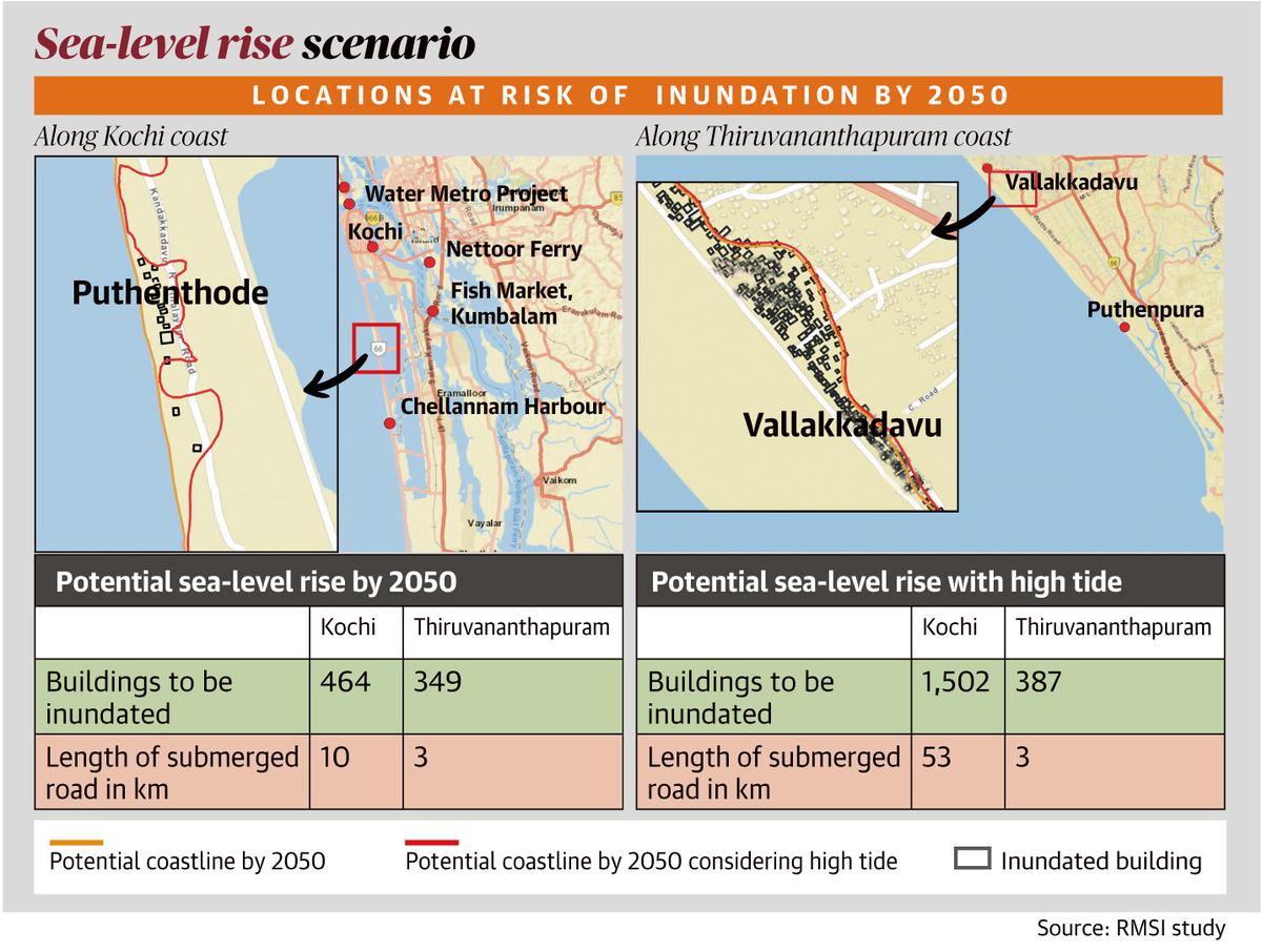
Situation in Kerala
- As per the two scenarios of potentially new coastline and coastline along with the high tide, 10 km and 53 km of road length will be impacted respectively.
- The road stretches include national and State highways as well as significant roads, namely ICT Road (NH 966 A), Indira Gandhi Road (NH 966 B), Aroor-Thoppumpady road (NH 66), Perumpadppe road (SH 66), Vellankanni Church Street (SH 66), Kumbalangi road, Saudi Manassery Road. It also includes Thoppumpady bridge, Paravoor-Cherai Road, Vypin-Pallipuram road, Goshree Road, Kelamangalam road, Ettupurackal road, Parayil Junction road, S Veluthully N road, Irappuzha road, Kunde Kadavu road, Monthachal Road, St Augustines Road and Poojapura road .
- The stretch along Star Road, airport–Valiyathura road, Lana Road, and Kovalam Beach road will be submerged by the potential sea-level rise.
Sea Level Rise (SLR):
- Increase in the level of the world’s oceans due to the effects of climate change, especially global warming, induced by three primary factors:
- Thermal Expansion: When water heats up, it expands. About half of the sea-level rise over the past 25 years is attributable to warmer oceans simply occupying more space.
- Melting Glaciers: Higher temperatures caused by global warming have led to greater-than-average summer melting of large ice formations like mountain glaciers as well as diminished snowfall due to later winters and earlier springs.
- That creates an imbalance between runoff and ocean evaporation, causing sea levels to rise.
- Loss of Greenland and Antarctic Ice Sheets: As with mountain glaciers, increased heat is causing the massive ice sheets that cover Greenland and Antarctica to melt more quickly, and also move more quickly into the sea.
- Sea level is primarily measured using tide stations and satellite laser altimeters.
Rate of SLR:
- Global: Global sea level has been rising over the past century, and the rate has accelerated in recent decades. The average global sea level has risen 8.9 inches between 1880 and 2015. That’s much faster than in the previous 2,700 years.
- Also, Intergovernmental Panel on Climate Change (IPCC) released ‘The Special Report on the Ocean and Cryosphere in a Changing Climate’ in 2019 which underlined the dire changes taking place in oceans, glaciers, and ice-deposits on land and sea.
- Regional: SLR is not uniform across the world. Regional SLR may be higher or lower than Global SLR due to subsidence, upstream flood control, erosion, regional ocean currents, variations in land height, and compressive weight of Ice Age glaciers.
Consequences of SLR:
- Coastal Flooding: Globally, eight of the world's 10 largest cities are near a coast, which is threatened by coastal flooding.
- Destruction of Coastal Biodiversity: SLR can cause destructive erosion, wetland flooding, aquifer and agricultural soil contamination with salt, and lost habitat for biodiversity.
- Dangerous Storm Surges: Higher sea levels are coinciding with more dangerous hurricanes and typhoons leading to loss of life and property.
- Lateral and Inland Migration: Flooding in low-lying coastal areas is forcing people to migrate to the higher ground causing displacement and dispossession and in turn a refugee crisis worldwide.
- Impact on Infrastructure: The prospect of higher coastal water levels threatens basic services such as internet access.
- Threat to Inland Life: Rising seas can contaminate soil and groundwater with salt threatening life farther away from coasts.
- Tourism and Military Preparedness: Tourism to coastal areas and military preparedness will also be negatively affected by an increase in SLR.
Steps taken to Tackle SLR:
- Relocation: Many coastal cities have planned to adopt relocation as a mitigation strategy. For example, Kiribati Island has planned to shift to Fiji, while the Capital of Indonesia is being relocated from Jakarta to Borneo.
- Building Sea Wall: Indonesia’s government launched a coastal development project called a Giant Sea Wall or "Giant Garuda" in 2014 meant to protect the city from floods.
- Building Enclosures: Researchers have proposed Northern European Enclosure Dam (NEED), enclosing all of the North Sea to protect 15 Northern European countries from rising seas. The Persian Gulf, the Mediterranean Sea, the Baltic Sea, the Irish Sea, and the Red Sea were also identified as areas that could benefit from similar mega enclosures.
- Architecture to Steer Flow of Water: Dutch City Rotterdam built barriers, drainage, and innovative architectural features such as a "water square" with temporary ponds.
Vulnerability of India:
- Communities along the coast in India are vulnerable to sea level rise and storms, which will become more intense and frequent.
- They will be accompanied by storm surges, heavy rain and flooding.
- Even the 0.1m to 0.2m rise expected along India in the next few decades can cause frequent coastal flooding.
- A speculator might think that if less than a metre sea level rise by 2100 is the likely scenario, they have another 60-80 years to continue developing infrastructure along the coast. That would not, however, be the right way to interpret the IPCC data.
- The uncertainty regarding a metre or more of sea level rise before 2100 is related to a lack of knowledge and inability to run models with the accuracy needed.
- Low confidence does not mean higher sea level rise findings are not to be trusted.
- In this case, the low confidence is from unknowns — poor data and difficulty representing these processes well in models. Ignoring the unknowns can prove dangerous.
- According to the UN Environment Programme Emissions Gap Report, the world is heading for a temperature rise above 3°C this century, which is double the Paris Agreement aspiration. And there is deep uncertainty in sea level projections for warming above 3°C.
India’s Efforts:
- Coastal Regulation Zone:
- The coastal areas of seas, bays, creeks, rivers, and backwaters which get influenced by tides up to 500 m from the high tide line (HTL) and the land between the low tide line (LTL) and the high tide line were declared as Coastal Regulation Zone (CRZ) in 1991.
- The latest regulation also takes into account rising sea-levels due to global warming.
- National Action Plan on Climate Change:
- It was launched in 2008 by the Prime Minister's Council on Climate Change.
- It aims at creating awareness among the representatives of the public, different agencies of the government, scientists, industry and the communities on the threat posed by climate change and the steps to counter it.
Exam track
Prelims Takeaway
- NAPCC
- Coastal Regulation Zone
- Findings of IPCC Report
Mains track
Q. The latest assessment of IPCC report is an eye-opener to the present condition of Climate change in India as well as global world. Discuss the steps taken in India and world to mitigate the effects of Climate change, especially the rising sea levels.